


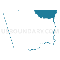
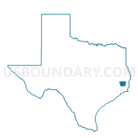
Voting District 0011, Hardin County, Texas
About
Outline

Summary
| Unique Area Identifier | 673619 |
| Name | Voting District 0011 |
| County | Hardin County |
| State | Texas |
| Area (square miles) | 82.17 |
| Land Area (square miles) | 81.52 |
| Water Area (square miles) | 0.66 |
| % of Land Area | 99.20 |
| % of Water Area | 0.80 |
| Latitude of the Internal Point | 30.47996250 |
| Longtitude of the Internal Point | -94.19940940 |
Maps

Graphs
Select a template below for downloading or customizing gragh for Voting District 0011, Hardin County, Texas


Neighbors
Neighoring Voting District (by Name) Neighboring Voting District on the Map
- Voting District 0002, Hardin County, TX
- Voting District 0008, Hardin County, TX
- Voting District 0012, Hardin County, TX
- Voting District 0015, Tyler County, TX
- Voting District 0015, Jasper County, TX
- Voting District 0016, Tyler County, TX
Top 10 Neighboring County Subdivision (by Population) Neighboring County Subdivision on the Map
- Silsbee CCD, Hardin County, TX (16,886)
- Kountze CCD, Hardin County, TX (12,508)
- Buna CCD, Jasper County, TX (10,633)
- Spurger CCD, Tyler County, TX (5,359)
- Warren CCD, Tyler County, TX (3,005)
Top 10 Neighboring Unified School District (by Population) Neighboring Unified School District on the Map
- Silsbee Independent School District, TX (16,892)
- Kountze Independent School District, TX (8,137)
- Buna Independent School District, TX (7,887)
- Warren Independent School District, TX (5,691)
Top 10 Neighboring State Legislative District Lower Chamber (by Population) Neighboring State Legislative District Lower Chamber on the Map
- State House District 12, TX (149,506)
- State House District 9, TX (145,381)
- State House District 19, TX (139,948)
Top 10 Neighboring State Legislative District Upper Chamber (by Population) Neighboring State Legislative District Upper Chamber on the Map
Top 10 Neighboring 111th Congressional District (by Population) Neighboring 111th Congressional District on the Map
Top 10 Neighboring Census Tract (by Population) Neighboring Census Tract on the Map
- Census Tract 303, Hardin County, TX (10,130)
- Census Tract 9507, Jasper County, TX (8,133)
- Census Tract 9504, Tyler County, TX (5,359)
- Census Tract 310, Hardin County, TX (4,154)
- Census Tract 9505, Tyler County, TX (3,005)
Top 10 Neighboring 5-Digit ZIP Code Tabulation Area (by Population) Neighboring 5-Digit ZIP Code Tabulation Area on the Map
- 77656, TX (17,110)
- 77612, TX (8,901)
- 77625, TX (8,489)
- 77664, TX (2,681)
- 77663, TX (1,353)
- 77616, TX (1,136)